


Peatland restoration planning tool and guide
Peatland erosion and drainage is common across Scotland. Often this is historical and its causes are hard to define, however we know that eroded or drained peat accounts for a significant proportion of the carbon emissions arising from Scotland and the UK, so it’s important we remedy this through restoration. This data and interface have been produced as an aid to peatland restoration, providing a tool that enables agencies, land managers and their advisors to target resources and funding where they are most likely to be effective in delivering large scale peatland restoration as rapidly and efficiently as possible.
The dashboard below allows query of the data at different spatial scales including Deer Management Group (DMG), Deer Management Units (DMU), land ownership units, or groupings of these.
A user guide for the dashboard is available here .
The dashboard can be either used in situ in this page or alternatively click on the expansion symbol in the top right of the window below to open it in a new tab (recommended). If dashboard items appear truncated changing the zoom level in the browser window (Ctrl + scroll) can help make content appear correctly.
Dashboard background
Peatland erosion and drainage data for Cairngorms National Park and adjoining land units is presented for exploration, query and download. This is primarily a strategic planning tool and not intended for detailed project design.
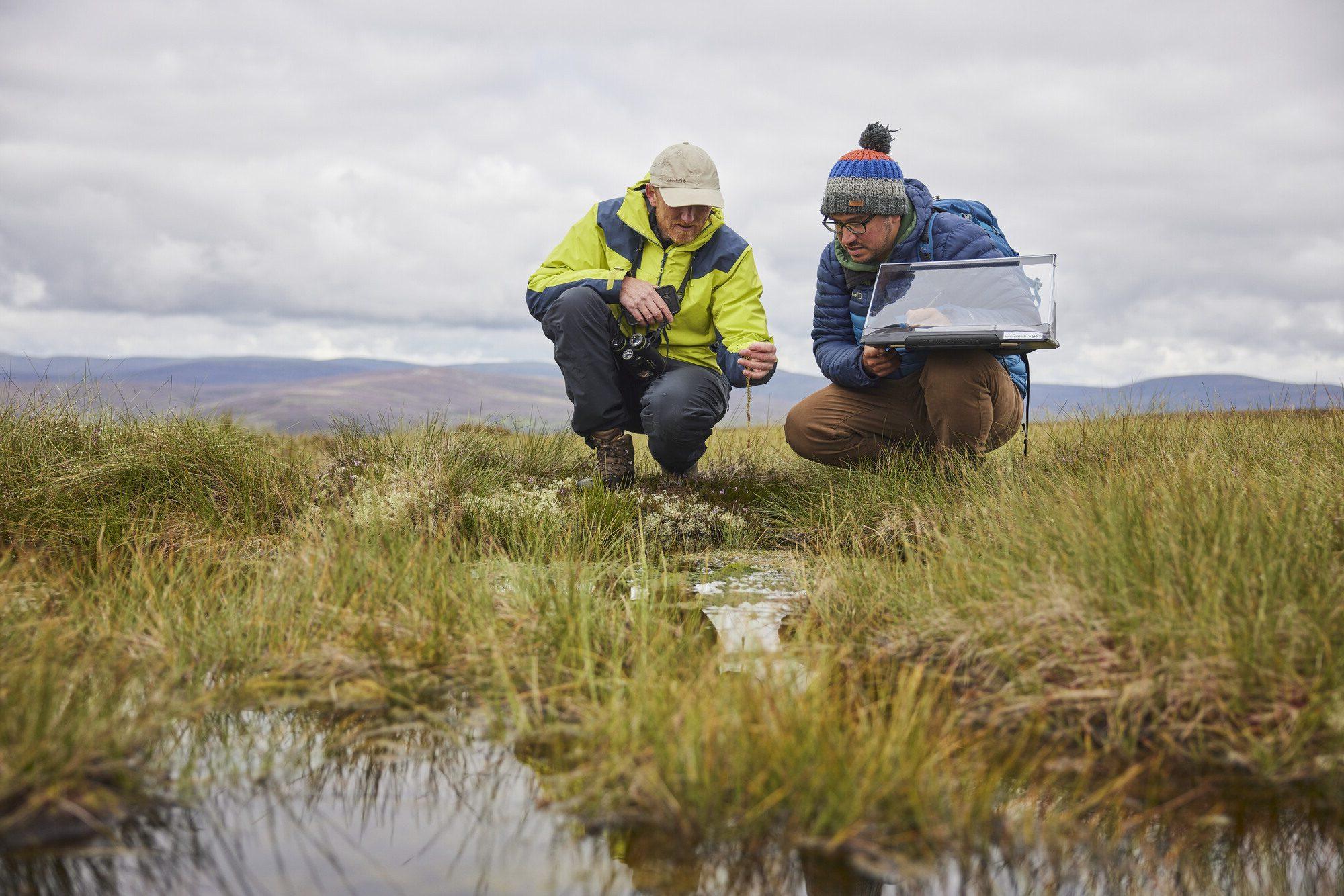
Erosion and drainage have been mapped by visual assessment of aerial imagery. A grid-based scoring methodology has been used to give an indication of location and intensity of these features. The methodology used to generate the data can be downloaded here.
The data is presented over a simplified map of the subject area, and the interface is designed for easy visual exploration of features in an area of interest. The map can be zoomed and panned and backdrop data can be changed to suit the viewer’s needs.
Note that DMG boundaries may not fully reflect current boundaries.
The data can be queried in a number of ways:
- Changing the map extent
- Selecting filters in dashboard header
- Selecting filter elements in the summary charts
Please bear in mind this is a large dataset and there may be a lag experienced when the map redraws or filters are applied. Occasionally blocks of data may appear to be missing, zooming in normally rectifies this.
Data download
Data download requires an ArcGIS Online account. If you do not have one through an organisation then a free public account can be set up by following the instructions on the ArcGIS Online help site . Once signed in (user details will appear at the top right) then the Export Data option highlighted below will be shown.
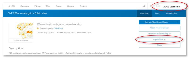
Layer details view showing logged in user and Export Data option
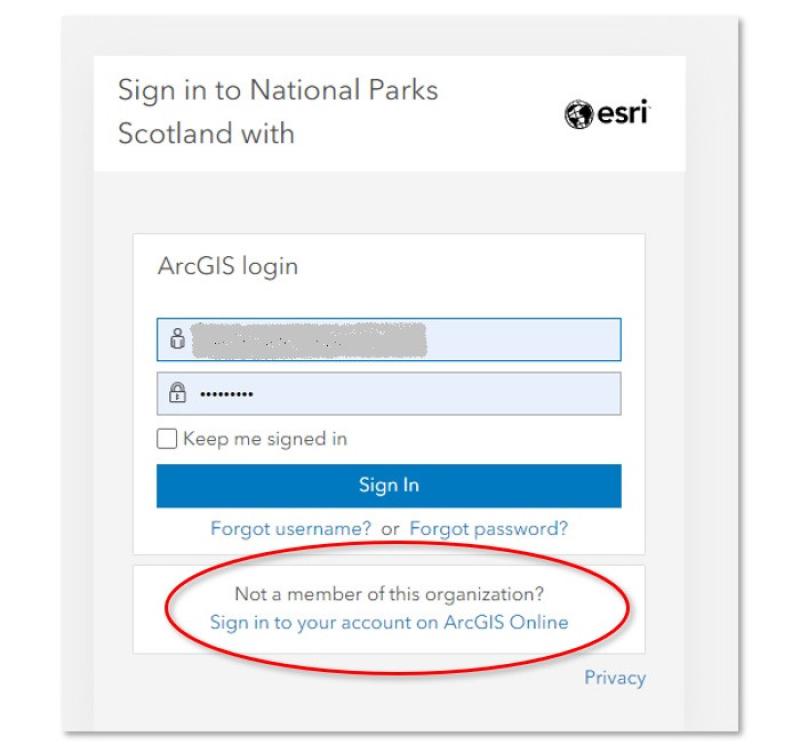
If the login screen shown below is prompted for at any stage then choose the lower option and log in with your AGOL [need to find out what acronym stands for] credentials.
The full dataset can be downloaded here . Clicking on Export Data gives the option to export to a variety of formats including Shapefile, File Geodatabase, KML and GeoJSON.
The gridded erosion and drainage data can be also downloaded via the web app below which allows a subset of the data to be selected using administrative units in the map or an imported shapefile.
Information on how to use the tool can be found in the i button.
The tool can be used either within this page or in a separate tab (recommended) by clicking on the expansion icon in the top right of the window below.
This tool is recommended for use only with subsets of the data. Selecting the whole dataset is likely to cause the web app to crash so the pathway described above should be used when larger areas of data are to be downloaded.
Alert
Featured
The new fire byelaw
How the Cairngorms National Park Authority and its partners are tackling the threat of wildfires, including details on the recreational fire management byelaw, in place from 1 April to 30 September each year.
Wildlife
The Cairngorms National Park is home to a quarter of the UK’s rare and endangered species. Its rich habitats are a haven for an array of wildlife, from iconic birds to elusive plants and flowers.
What we do
From pioneering conservation projects to community engagement and active travel, find out more about the range of work happening across the National Park.
Relevant alerts
-
Update - 21:55
The Scottish Fire and Rescue Service have shared that emergency services continue to tackle a large-scale wildfire covering more than two kilometres in width near to Glenmore.
A number of homes and businesses, including campsites and ski resorts within the Glenmore Forest Park area, have been closed and evacuated as a safety precaution due to the close proximity to the incident.
As of 9pm on Wednesday night (15 July), Scottish Fire and Rescue Service currently has six fire appliances, a wildfire unit, specialist resources and tactical commanders mobilised to the scene after the alarm was raised just before 12 noon earlier today.
Firefighters are working with landowners to contain the incident and create fire breaks, with high winds causing the fire to spread across areas of trees and woodland. There are no reported casualties.
Road closures continue to be in place to support the emergency response, and people are asked to avoid the area within Glenmore Forest Park and Loch Morlich on Thursday, 16 July as this incident continues.
We will share updates as the situation develops. In the meantime, our thanks go out to the emergency services, gamekeepers, NGO and estate staff and many others from across the community who are working non-stop to get these fires under control, and providing support to those affected.
Update - 20:06
Emergency services and partners are continuing to respond to this wildfire. A number of properties and premises in the area have been evacuated as a precaution. The Ski Road is currently closed. Anyone walking in the Cairngorms should avoid the area and let family or friends know when they have returned.
----
The Scottish Fire and Rescue Service and partners are currently in attendance at a large fire in the open near to Ryvoan Bothy within the Cairngorms National Park.
Due to large volumes of smoke travelling towards populated areas nearby, residents in Aviemore, Glenmore and the surrounding communities should keep their windows and doors closed. If you are within this area and can see or smell smoke, please follow the same advice. If you are aware of someone hiking in the area, please ask them to get themselves safely off the hill as soon as possible.
The Scottish Fire and Rescue Service has asked that people avoid the Glenmore and Aviemore area, and remain vigilant. Our thanks go to all those engaged in active firefighting - we will post further updates when we have them.
-
Very high fire risk - 15 to 20 July
The Scottish Fire and Rescue Service has issued a very high wildfire warning impacting areas of the National Park on Wednesday 15 until Monday 20 July. If you are out and about in the Cairngorms National Park please observe the following guidance:
- Do not light any fire or barbecue, in line with the new fire byelaw
- Always ensure cigarettes are fully extinguished and take your litter (including glass) away with you
- Enjoy the outdoors responsibly - most wildfires are caused by human activity
- Stay alert - with dry vegetation and warm weather, fires can start easily, spread rapidly, and burn intensely
- If you see a wildfire, dial 999
For further updates on wildfire risk across Scotland, visit the Scottish Fire and Rescue Service website. To find out more about the fire byelaw, and to see your questions answered, visit our fire byelaw page here.